Tuesday, February 26, 2008

On the Road to Tucson (4) Carlsbad & Las Cruces

February 26-27, 2008. Carlsbad Caverns National Park has to be the most impressive natural wonder that we've ever seen. We've been to a few caves, including Mammoth Cave, but none compare to the immense rooms and fantastic creations in Carlsbad. Words cannot adequately describe this awesome park. And neither can pictures but I did get a few decent ones.

Carlsbad is in southeast New Mexico within the Guadalupe Mountains of the Chihuahuan Desert. The cave was discovered in the late 1800's by a cowboy who saw bats emerge. He was intrigued and began exploring the cave. It was not formed by flowing water as Mammoth Cave was. It began forming 250 million years ago as a 400 mile long reef of a large sea composed of sponges, algae and seashells. As the sea retreated the reef was buried under salts and gypsum and cracks developed. A million years ago there was an uplift of the tectonic plate which allowed rain to seep down through the cracks. The stalactites and stalagmites began forming about 500,000 years ago from hydrogen sulfide mixing with water to form sulfuric acid which dissolved the limestone. The result was calcite hardening on the outside of the drips. It was amazing to think that the formations we were looking at formed so long ago. (From late March to October you can hear a talk about the bats and see them leave their cave at dusk. But right now they're still in warmer Mexico.)

We arrived in time to do a self-guided walk into the Big Room using the Natural Entrance. The cave is 56 degrees and the biggest room is 1075 feet tall. We spent about 2 hours down there! Here are pictures of the area outside the cave, the natural entrance and the long switchbacks down to the bottom. You can also take the elevator down which they make everyone take back up. (They were renovating the Visitor Center which was supposed to reopen in June.)


There are a number of different kinds of formations in the cave. I don't have a name for the first one but the next ones are drapery, straws, and popcorn.


Here are some interesting formations from the Big Room.

We took 2 guided tours. The first was the Left-hand Tunnel where we went in with candle lanterns. Here are some formations from that tunnel.


The tour of King's Palace was much more impressive with its huge rooms and interesting formations. Both guides gave pretty much the same general information. Some of these pictures may be from the Big Room since after the tour we spent another hour walking around and gawking at the formations.


February 28-29, 2008.
Las Cruces, New Mexico isn't all that far from the border of Mexico so here and there in northern Texas and around Las Cruces there are Border Patrol stops. At one the officer saw we were from Massachusetts, asked where, and told us he was from Gardner and his aunt lived in Northampton!

We went to a small Natural History Museum at a mall which was a really good children's museum. We also went to a museum at the New Mexico State University where there were interesting exhibits on the depression in that area and pottery. We walked around the gorgeous campus and found the theater that was having a production. The next night we enjoyed the play, "Reckless" by Craig Lucas. It was really, really enjoyable and well done by the students.

Dripping Springs was where we decided to hike. It was all uphill but had an interesting old mountain camp which was turned into a TB sanatorium in the early 1900's.

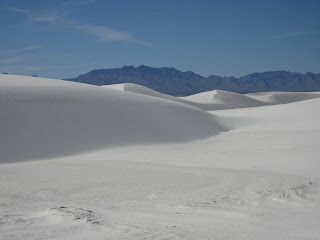
After reading an article in the USA Today we decided to check out White Sands National Monument. We are so glad we did. It was amazing. It's at about 4000' elevation. Imagine 275 total square miles of dunes, if you can. Only 115 square miles are actually located within White Sands National Monument, the rest are part of the White Sands Missile Range. There was a great Visitor Center with a short movie and displays. We learned that these sand dunes are like no other because the sand is made of gypsum. The simplified explanation is that gypsum leaches out of the mountains when it rains, dries up, crystallizes and gets blown away. This obviously has gone on for thousands of years. And every year the dunes move a few inches to the northeast (away from the missile range). Some have vegetation: yucca, small trees and shrubs and some are bare. It looked like huge snow drifts. One interesting thing is that because of all the blowing sand they actually have to use a snow plow on the roads!

Because of blowing sand and the heat, here is their unique set-up for picnic tables.

We decided to do the 4.5 mile round trip Alkali Flat Trail. (Finally, after 2 miles we reached the "flats.") It was only 75 degrees but felt like 85 with the reflection of the sand. Fortunately there wasn't blowing sand but there was a breeze. It was a hike unlike any other. We walked up and down sand dunes following stakes that were trail markers. In a few places we saw the top 2 inches of trail markers and then new ones they had put in! You can see how tall some of the dunes were. Here I am next to one. It was exhausting but really a very cool hike.



At one point we met a couple of retired teachers from London, Ontario (Brian and Bernie Legg). We started talking about retirement travel and found out that they rented a friend's condo in Ft. Myers every November-December. Not only that but it's in Heritage Palms where the Hurwitz's condo is. We exchanged emails and plan on reconnecting next winter.

Here's a typical scene from northern Texas and southern New Mexico, an oil rig.

Next adventure: March in Tucson, Arizona.

On the Road to Tucson (3) Big Bend National Park

February 23-25. Big Bend National Park is located in southwest Texas on the Rio Grande River bordering Mexico. It's huge! It's a really desolate area but it has a stark beauty. There are mountains, desert, and water!

We stayed at the Chisos Mining Co. Hotel in Terlingua since we wanted a kitchen. It was basic but it did have AC and worked out fine. There was a nice sunset one night and the stars we saw reminded us of the Grand Canyon.


We hiked about 5 hours every day, in 2, 3 or 4 separate hikes. Sarah Collins had recommended 2 hikes: Grapevine and Lost Mine. We hiked Grapevine Hills trail first. It was 60 degrees but sunny and windless so it felt much warmer. All of a sudden I heard "Whoosh-whoosh." I looked up and there was a black vulture overhead. We've never before heard the sound of a bird's wings that were so far away. (We've heard hummingbirds close to us.) Common in much of the desert here is prickly pear cactus, the red, purple, and blind (no spines), cholla, ocotillo and various other plants. There was a little rock scrambling at the end but the Balanced Rock was really cool. And what a great view from there. We couldn't get over the blueness of the sky. As we drove the unpaved road to get back to the main road we saw 3 javelina crossing. One person said they were really a road hazard because they stay in packs and cross the road slowly.


We took a guided hike of Tuff Canyon, a very different formation. It was white volcanic rock. We also learned two new words: dikes are uplifted rock that looks likes like it's poking out of the ground, breccia is like a conglomerate but the bits of rock are angular and sharp. Our tour guide was a volunteer like many. Besides the informative talk we found out that he (Ted Rowan) was a retired earth science teacher from Falmouth, MA. He knew Charlie Camp who spent 1 year teaching there and also knew our friends, Sharon and Ken Chapman. Ken was assistant principal of Fort River when it opened. Sharon used to teach math at ARHS and now teaches at Falmouth HS.


By the time we hiked the very pretty Santa Elena Canyon in the late afternoon it was up to 85 and felt pretty warm. We walked across a creek that fed into the Rio Grand River and on up the canyon. It was actually cooler there because there were tall grasses next to the river.


The next day was predicted to be warmer so we headed up to the Chisos Visitor Center at 5400' elevation. What a nice change of scenery: spruce, pine trees, juniper and oak trees - just lots of green. We saw 2 mule deer on our way down the Window Trail which led through a dry river bed that cut a path through the rock.


A short hike took us to a good view of a mountain aptly named Mule's Ears.


The Lost Mine trail was our most strenuous hike as it took us from 5600' to 6850'. It was steep and there were a lot of switchbacks so I was glad I had my hiking poles (a retirement gift from work). The views were gorgeous. It was actually very windy at the top and it was hard to even talk - but it wasn't hot!!


A


A sign outside Terlingua read "Loose Cattle." And you thought Texas cattle were all safely behind fences! (We didn't actually ever see cows roaming like in Belize.) Gas was $3.46/gallon here although the farther north we drove the less expensive it became. It's always hard to guess what the gas prices will be in another town. And we really haven't bothered to check online. It was wonderful hiking in Big Bend but we were looking forward to going underground in Carlsbad, NM.

On the Road to Tucson (2) San Antonio & Austin

February 19-22. San Antonio and Austin, about an hour apart, were great cities to walk around and see the sights. We decided to spend 2 days in each, while staying in San Antonio. (We even got to eat Texas-shaped waffles at the Residence Inn!)

Our first stop in San Antonio was at the Conservation Society to pick up a self-guided walking tour of the historic downtown. One our way there we met a couple from northern Ontario admiring the old victorian houses, those renovated and those needing renovation. They were on a Friendship Force trip. This is a travel exchange started during the Carter presidencey. (thefriendshipforce.com) Sounds intriguing. I'll have to get more information.

We parked for free in a residential neighborhood and walked about 15 minutes to the Rivercenter Mall where we saw an IMAX movie, "The Alamo...The Price of Freedom." The 40 minute movie (for $10.50) was a re-enactment done by the History Channel. It was excellent. Finally, I understand the significance of "Remember the Alamo." In 1836 the Texas Territory declared independence from Mexico (most residents were from America & Europe). The President didn't like that so he stormed the fort. (The name Alamo was taken from the town that the Mexican military was from who occupied the fort in the early 1800's. Before that it was a mission.) The Texans were greatly outnumbered but fought to the bitter end to defend their right to freedom and independence. Unfortunately, they were all killed by the Mexican troops. Within a month Sam Houston defeated the Mexicans and Texas finally got its independence. The Alamo is basically a memorial to those courageous people who died, two famous ones being David Crocket and James Bowie. There are artifacts, historical information and a short movie (a good complement to the IMAX movie).


The Riverwalk is gorgeous - a great way to spend some time walking and people watching. It's also cooler by the water. What an amazing idea, first conceived in 1929 after the 1921 flood. It was finally finished in 1941 as a WPA project. There are stores, hotels, and restaurants with walks, waterfalls and beautiful landscaping along a 2 1/2 mile stretch of the San Antonio River. It was really relaxing to eat our lunch at a table next to the river watching ducklings and small cruise boats, with Andean music in the background. Later we took the informationative 20 minute cruise. On our next visit (in November) we'll go at night when the trees are lit up like it's Christmas!


For 50% off we went back to the IMAX theater and saw the story of Lewis and Clark made by National Geographic. It was excellent and added to the information we got from a book on tape we had listened to a couple of years ago. What courageous people they were!

At the Witte Museum we learned a lot about the geography of Texas. Wow, Texas has a little bit of almost everything: desert, plains, woods, mountains, prairie, and swamps/marshland. There were also good displays of the Native Americans who lived here.

Austin is in a little higher elevation than SA, partly in the "hill country". The Visitor Center had a bunch of different walking tours and we chose Congress Street since we were headed up that street anyway to tour the Capitol. (We've found that visiting capitol buildings gives us great overall information on a state.) We saw interesting old architecture. The Driskill Hotel was gorgeous with a stained glass dome on a hall ceiling. And where else but in Texas would you find not a leather couch but a cow-hide couch!


We had a really enthusiastic tour guide for the capitol, the tallest of all the US capitols, taller even than the US Capitol Building! (Who's surprised?) The billboard says it all. One interesting thing was that after an election pictures of all the new legislators are displayed along with pictures of their children and grandchildren!


The Lyndon Baines Johnson Library and Museum on the UT campus was excellent! Opened before LBJ died, it displayed the highlights of history in words, pictures, and video from LBJ's birth in 1908 until his death in 1973. (It's the only presidential library that's free, per LBJ's request.) On the 4th floor was a 1/8 scale model of his Oval Office as well as photos of other main rooms in the White House along with Ladybird's oral description. They even had a role player of Sen. Johnson in 1959 give a speech and take questions. We continue to learn more history.

A hike up Mt. Bonnell gave us a great view of the Colorado River (not the same one that flows through the Grand Canyon) and the big, beautiful homes below each with their own boat slip. What a great view! Homes on the other side were just as large.

Thursday (2/21) was a pretty exciting day in Austin. We took a walk through the UT campus as they were prepping for the Clinton/Obama debate: lots of TV vans, cameramen, portable fences, secret service men, and people with campaign signs.

The Texas History Museum, very close to campus, was excellent. Texas is a unique state. Besides their slogan "Everything is begger in Texas," they showed a movie promoting pride in being a Texan and "anything is possible." It was a real rah-rah movie. (Did you know that Texan students pledge allegiance to the flag of Texas?) The museum was organized really well: Encounters on the Land, Building the Lone Star Identity, and Creating Opportunity (ranching, oil, etc.). There was also a very interesting special exhibit of first person accounts of historical events like Thomas Jefferson observing the first violence of the French Revolution and President Carter's notes on a private meeting with Pope John Paul II. We also saw another IMAX movie there, "Dolphins and Whales." I've never seen them up so close. It was very cool!

Our visit to Austin was capped off with a delicious dinner with friends at Chez Zee. We met Colleen Schmitt, her fiance Jason, and Sarah Collins there. We've known Colleen since she was little and are friends with her parents. Sarah is a friend of Scott's and we've known her and her parents since junior high. They all work in Austin. It was really a fun evening, with never a pause in conversation!


Next adventure: Hiking in Big Bend National Park on the Mexican border.